 | |
| day-15.gpx | Gogle Maps GPX Viewer |
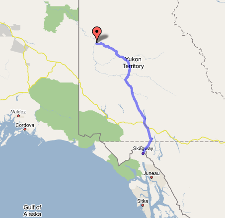
Dawson City, YT to Skagway, AK
Big relief today, as the iffiest portion of the trip is now successfully over: the trip over the top to Dawson and down to Skagway in two days of hard driving. Here we are, and with time to spare!
Unfortunately today dawned just as smoky as yesterday, after probably the coldest night of the trip to boot. Naturally, we were camping, in thin sleeping bags on rocks. I knew we'd regret not having those pads that I stupidly left at home! I got an okay amount of sleep (no thanks to some rowdy kids screeching around Dawson's dirt streets all night), but Paul didn't seem to get a single wink. Poor guy. I didn't begrudge him a couple of power naps as we drove south on the Klondike Highway, now well and truly pointed in the direction of home. First we gassed up at the Esso just south of town and got some little ham & cheese sandwiches to fuel us down the long road; then we set out into the dingy grayish-brown gloom.
Now, one thing Paul and I had inevitably noticed in Alaska was that everywhere we went, on every highway we saw from the Parks to the Taylor, every single road sign had been riddled with bullet holes and shotgun blasts. We'd written it off as crazy rural Alaskans exercising the inevitable redneck streak that frontiersmen-types pretty much have to have; but we were both surprised to find that the same tradition seems to be in vogue in the Yukon as well. Even Canada's generalized scowl toward gun ownership doesn't seem to dull the spirits of the Yukon's doughty denizens.
Anyway, the drive south (320 miles) from Dawson to Whitehorse would surely have been quite pretty if we'd been able to see anything through the smoke; I got a pretty good idea of it, though, and honestly I think it would have been one of the more boring stretches of road on the trip regardless of the weather. Lots of impenetrable trees (birches and those scrubby spruces) on both sides of the road as it passed through the Yukon, Stewart, Pelly, and other river valleys; the only interruptions, aside from dipping down to cross rivers, were the sign-marked regions of scarring from past forest fires. I saw what might have been a coyote or even a wolf some distance down the road, but it disappeared before I could snap a picture; Paul, as mentioned, slept. Finally we passed Fox Lake (would have been very pretty without the burned trees and smoky air), then Lake Laberge, which wasn't visible from the road, and then rejoined the Alaska Highway just north of Whitehorse. Odd how familiar it all looked.
Stopped in town for gas and to get sandwiches at the Real Canadian Superstore, which is sort of like a Safeway cross-bred with a Target and put in a Wal-Mart-sized box. Good sandwiches, though, and friendly clerks. I got a much better impression of Whitehorse this time through, perhaps because it wasn't raining, and perhaps because we didn't go to the depressing Qwanlin Mall. With sandwiches in hand and a full tank (the gas station was all out of those "Whitehorse Fire Department" male pinup calendars, which apparently were a hot seller), we departed Whitehorse at about 2:30; took the South Klondike Highway toward Skagway just south of town. This road rose steadily until large mountains loomed ahead through the haze. Before we knew it we were in Carcross, site of a caribou crossing (hence the name) and a strange tiny high desert with sand dunes and everything. Then there was a series of long, narrow canyon lakes with dramatic mountain backdrops leading us higher and into the British Columbia panhandle, which someone we talked to the other day had described as her favorite spot on the entire Earth. By Fraser, it was easy to see why: not just those gorgeous canyon lakes, but also a bizarre moonscape of granite archipelagos ringed and run through by an endless network of little lagoons flowing and cascading into each other, like huge versions of tidepools at the beach. This sight—which I've never seen the like of anywhere else before—went on from Canada Customs all the way to White Pass, where suddenly we found ourselves in the U.S. again without having passed Customs. (No room for the facility at the border—on both sides it's several miles down the canyon.) On the Skagway side it's an absurdly steep V-shaped canyon leading down to the ocean in about ten miles. And between this and the Chilkoot Trail, White Pass was the easier one for the miners! We stopped at a waterfall halfway down the canyon for some photos, then reached U.S. Customs, where the lady waved us through with only the briefest of formalities. Then we were in Skagway—and before 5:00 (local time) at that.
So we found our hotel, the Westmark, which I'd paid for in advance; parked on the street, as the hotel (and the whole town) is set up more to cater to people coming off cruise ships and tour buses than people driving in over White Pass. But that also meant everything in town is within walking distance. Went down to the waterfront to see the docked Holland America ship, then to a little bistro-and-everything shop where despite employees who seemed not to be on the clock, we got an outstanding mushrooms-and-feta-cheese pizza for a good price. Returned to the room to find we had an entire evening to kill; considering last night's rocky experience in the cold smoky North, it seems the thing to do to get a whole bunch of very good sleep. It'll be our last chance till Prince George, anyway, so I'll close now. Tomorrow—to the ferry dock at 8:00!