 | |
| day-03.gpx | Gogle Maps GPX Viewer |
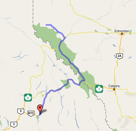
Kelowna, BC to Grande Cache, AB
We didn't make Dawson Creek today—but it was a very satisfying day nonetheless! Checked out of our sumptuous suite in Kelowna around 8:00, and stopped by my company's building, which was on a dirt street (it's being renovated), and closed for the holiday. (Of course.) We'd stopped at the company's main headquarters in Cupertino on the way up, and it would have been fun to say hi to the people in the northern R&D office, but it wasn't to be. So we pressed on through the dramatic canyonlands I'd become used to ever since Wenatchee—maddeningly slow to traverse, beautiful though they may be. Picked up the Trans-Canada Highway at Sicamous; rose gently with the river canyon and lakes into the Rockies, which I'd never seen north of the border before.
Crossed the upper Columbia at Revelstoke, where we got gas at a very harried Petro-Canada—we had to wait in line and jockey for position with U-Haul trucks and vacationers from many countries, not all of whom understood about the pumps that only gave one grade per specific pump (if you pulled up to the wrong pump, you had to pull out and get back in line, hopefully not behind a giant truck that needed a complete fill-up). Then we rose into the Rockies in earnest, seeing enormous snow-topped rock edifices in Glacier National Park (the highway went through avalanche sheds in many places—way steeper terrain than most major highway roadbeds), and huge glaciated canyons that made for great photos, even from the moving car. Still, progress seemed slow, and we stopped for lunch at an A&W in the little hamlet of Golden in a striking north-south valley that turned out to be the Columbia again in another, higher-altitude arm, and which presaged the valley just to the east in Banff/Jasper, where our trail took us next. I'd hoped to be eating lunch somewhere in Banff—but then again, where in Banff? So I guess it worked out fine.
After paying $16 Canadian for the privilege, we turned north on the Icefields Parkway (Alberta 93), which follows the canyon north through both parks for about 120 miles. I thought I'd known what to expect, but neither of us was prepared for the enormousness of the mountains flanking both sides of the long, long valley, and the glaciers, lakes, and waterfalls regularly dotting it. Got tons of great photos—probably so many that they'll all become indistinguishable in the final presentation. A rainstorm moved in on us as we entered Jasper over the only dividing highlands in the middle of the north-south valley, and it seemed to bring out the wildlife—we saw mountain sheep grazing at the roadside near Athabasca Falls, another spot where we took photos, rain or no rain. Yet the strict 70-90 km/h speed bugged me, and it was 6:00 by the time we left the park, and 7:00 before we reached Hinton on the Yellowhead Highway (AB 16), on which we'd seen sheep, deer, moose, and a huge, close-looking rainbow. All of these except the rainbow were picked out by startlingly accurate hazard signs: deer were hanging out next to the "deer" sign, sheep next to the "sheep" sign. Very law-abiding animals.
Finally we exited the Rockies and landed in the edge-of-the-plains town of Hinton, where we gassed up and ate at Monsters Pizza (pleasant small-town atmosphere, even if the pepperoni was weird and bologna-like). Now, I had been looking askance at the daunting-seeming AB 40 road up to Grande Prairie and Dawson Creek, thinking it looked inefficient and desolate, with its huge hairpin turn (that seemed to indicate an underdeveloped road through a steep canyon) and few apparent services. But signs at the road's turnoff called it a "Scenic Route to Alaska", so we scuttled our tentative plans to go the long way around through Edson and Whitecourt (almost to Edmonton), and broke out the Milepost for the first time to hear what it had to say on the subject of AB 40, the Bighorn Route. It gave us to understand that Grande Cache, halfway up the road, was a substantial town with many amenities; so we phoned ahead to the Big Horn Inn, advertised in the book, where we were told a shining tale of low prices and lots of spare rooms. So off we went. And what a road! Gentle rolling hills skirting the mountains, foothills on our left. Virtually no traffic, except for the occasional RV or logging truck. We followed the sunset the whole way, and at dusk (8:30-9:00—seems we're making northward progress) the faunae came out to play, and we kept our eyes peeled for deer, which made frequent appearances. Finally we pulled in to the motel at the surprisingly well-appointed-looking town of Grande Cache, checked in, and enjoyed our first semi-leisurely evening, watching the History Channel show on the Alcan Highway (that we'd brought on DVD), and downloading the hundreds of photos we'd taken in Banff/Jasper. The motel is "rustic" but clean, and I look forward to a good night's sleep and our first leg of the Alaska Highway tomorrow!